![](/images/other/stat-length.png)
![Tocht Stappen Bassillac et Auberoche - Eyliac Milpas - Photo](https://media.geolcdn.com/t/1900/400/ext.pjpeg?maxdim=2&url=https%3A%2F%2Fstatic1.geolcdn.com%2Fsiteimages%2Fupload%2Ffiles%2F1553511878bg_sport_marche.png)
Eyliac Milpas
pascalmilpas
Gebruiker
![Lengte](/images/other/stat-length.png)
Lengte
12,4 km
![Max. hoogte](https://static1.geolcdn.com/siteimages/upload/files/1508320355ic_sort_altitude_max_24dp.png)
Max. hoogte
235 m
![Positief hoogteverschil](https://static1.geolcdn.com/siteimages/upload/files/1508320355ic_sort_den_pos_24dp.png)
Positief hoogteverschil
258 m
![Km-Effort](/images/other/stat-length.png)
Km-Effort
15,8 km
![Min. hoogte](https://static1.geolcdn.com/siteimages/upload/files/1508320355ic_sort_altitude_min_24dp.png)
Min. hoogte
131 m
![Negatief hoogteverschil](https://static1.geolcdn.com/siteimages/upload/files/1508320355ic_sort_den_neg_24dp.png)
Negatief hoogteverschil
253 m
![Boucle](https://static1.geolcdn.com/siteimages/upload/files/16400158638029165_repeat_loop_refresh_sync_direction_icon.png)
Boucle
Ja
Datum van aanmaak :
2023-11-28 08:06:46.747
Laatste wijziging :
2023-11-28 19:36:18.23
![Stappen](https://static1.geolcdn.com/sitytour/trail-icons/101.png)
3h02
Moeilijkheid : Moeilijk
![Scan deze QR-code om de tocht te openen in de SityTrail-applicatie](https://capi.geolives.com/qq0zvz2zws4bq2lad0pu/sitytour/trails/3878932/qr.png?size=200)
Gratisgps-wandelapplicatie
Over ons
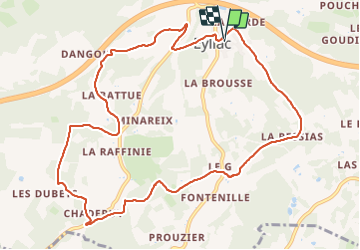
Tocht Stappen van 12,4 km beschikbaar op Nieuw-Aquitanië, Dordogne, Bassillac et Auberoche. Deze tocht wordt voorgesteld door pascalmilpas.
Beschrijving
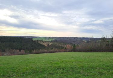
Boucle PDIR bien balisée classiquement en jaune
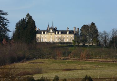
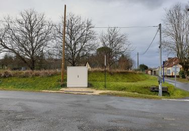
Petit raccourci hors boucle au niveau du Chateau du Puy après 8,5 kms, économisant env. 500M et une côte raide.
Joli parcours, belles forêts, parfois un peu boueux, et donc attention en cas de pluie fortes
Plaatsbepaling
Land:
France
Regio :
Nieuw-Aquitanië
Departement/Provincie :
Dordogne
Gemeente :
Bassillac et Auberoche
Locatie:
Unknown
Vertrek:(Dec)
Vertrek:(UTM)
331511 ; 5003116 (31T) N.
Opmerkingen
Wandeltochten in de omgeving
![Tocht Stappen Bassillac et Auberoche - Le Change Roc 9km - Photo](https://media.geolcdn.com/t/375/260/ext.jpg?maxdim=2&url=https%3A%2F%2Fstatic1.geolcdn.com%2Fsiteimages%2Fupload%2Ffiles%2F1553511878bg_sport_marche.png)
![Stappen Stappen](https://static1.geolcdn.com/sitytour/trail-icons/101.png)
Le Change Roc 9km
Stappen
Heel gemakkelijk
(1)
Bassillac et Auberoche,
Nieuw-Aquitanië,
Dordogne,
France
![](/images/other/stat-length.png)
9,3 km | 12,2 km-effort
2h 43min
![](https://static1.geolcdn.com/siteimages/upload/files/16400158638029165_repeat_loop_refresh_sync_direction_icon.png)
Ja
![Tocht Stappen Bassillac et Auberoche - Le Change Pommiers 9km - Photo](https://media.geolcdn.com/t/375/260/ext.jpg?maxdim=2&url=https%3A%2F%2Fstatic1.geolcdn.com%2Fsiteimages%2Fupload%2Ffiles%2F1553511878bg_sport_marche.png)
![Stappen Stappen](https://static1.geolcdn.com/sitytour/trail-icons/101.png)
Le Change Pommiers 9km
Stappen
Gemakkelijk
(1)
Bassillac et Auberoche,
Nieuw-Aquitanië,
Dordogne,
France
![](/images/other/stat-length.png)
9 km | 11,3 km-effort
2h 32min
![](https://static1.geolcdn.com/siteimages/upload/files/16400158638029165_repeat_loop_refresh_sync_direction_icon.png)
Ja
![Tocht Te voet Bassillac et Auberoche - Les chabannes - Photo](https://media.geolcdn.com/t/375/260/a8aade46-e147-4b35-b4a7-c1d555488ef4.jpg&format=jpg&maxdim=2)
![Te voet Te voet](https://static1.geolcdn.com/sitytour/trail-icons/100.png)
Les chabannes
Te voet
Gemakkelijk
Bassillac et Auberoche,
Nieuw-Aquitanië,
Dordogne,
France
![](/images/other/stat-length.png)
6,3 km | 8,2 km-effort
1h 52min
![](https://static1.geolcdn.com/siteimages/upload/files/16400158638029165_repeat_loop_refresh_sync_direction_icon.png)
Ja
![Tocht Te voet Saint-Pierre-de-Chignac - Boucle du Lavoir - Photo](https://media.geolcdn.com/t/375/260/e386a542-1ce6-4d44-946f-087c4c01d831.jpeg&format=jpg&maxdim=2)
![Te voet Te voet](https://static1.geolcdn.com/sitytour/trail-icons/100.png)
Boucle du Lavoir
Te voet
Gemakkelijk
Saint-Pierre-de-Chignac,
Nieuw-Aquitanië,
Dordogne,
France
![](/images/other/stat-length.png)
5,3 km | 7,1 km-effort
1h 37min
![](https://static1.geolcdn.com/siteimages/upload/files/16400158638029165_repeat_loop_refresh_sync_direction_icon.png)
Ja
![Tocht Te voet Saint-Pierre-de-Chignac - Boucle de la Chapelle - Photo](https://media.geolcdn.com/t/375/260/d3c39e97-2e4b-4bda-bfae-5ac5d4c513f2.jpeg&format=jpg&maxdim=2)
![Te voet Te voet](https://static1.geolcdn.com/sitytour/trail-icons/100.png)
Boucle de la Chapelle
Te voet
Gemakkelijk
Saint-Pierre-de-Chignac,
Nieuw-Aquitanië,
Dordogne,
France
![](/images/other/stat-length.png)
14,7 km | 18,7 km-effort
4h 14min
![](https://static1.geolcdn.com/siteimages/upload/files/16400158638029165_repeat_loop_refresh_sync_direction_icon.png)
Neen
![Tocht Stappen Saint-Pierre-de-Chignac - boucle chai lamardie - Photo](https://media.geolcdn.com/t/375/260/21e6bc13-c5ca-4323-a746-a80ff6aa9b77.jpg&format=jpg&maxdim=2)
![Stappen Stappen](https://static1.geolcdn.com/sitytour/trail-icons/101.png)
boucle chai lamardie
Stappen
Gemakkelijk
Saint-Pierre-de-Chignac,
Nieuw-Aquitanië,
Dordogne,
France
![](/images/other/stat-length.png)
8,6 km | 11 km-effort
2h 45min
![](https://static1.geolcdn.com/siteimages/upload/files/16400158638029165_repeat_loop_refresh_sync_direction_icon.png)
Ja
![Tocht Te voet Saint-Crépin-d'Auberoche - Boucle de la Tuillère - Photo](https://media.geolcdn.com/t/375/260/43b94199-7445-405d-8654-dfea16f06fd9.jpeg&format=jpg&maxdim=2)
![Te voet Te voet](https://static1.geolcdn.com/sitytour/trail-icons/100.png)
Boucle de la Tuillère
Te voet
Gemakkelijk
(1)
Saint-Crépin-d'Auberoche,
Nieuw-Aquitanië,
Dordogne,
France
![](/images/other/stat-length.png)
7,6 km | 9,5 km-effort
2h 9min
![](https://static1.geolcdn.com/siteimages/upload/files/16400158638029165_repeat_loop_refresh_sync_direction_icon.png)
Ja
![Tocht Te voet Saint-Crépin-d'Auberoche - Boucle de la Tuillère (Variante courte) - Photo](https://media.geolcdn.com/t/375/260/fae48319-4f5c-4d98-9f56-fe274312e9a7.jpeg&format=jpg&maxdim=2)
![Te voet Te voet](https://static1.geolcdn.com/sitytour/trail-icons/100.png)
Boucle de la Tuillère (Variante courte)
Te voet
Gemakkelijk
Saint-Crépin-d'Auberoche,
Nieuw-Aquitanië,
Dordogne,
France
![](/images/other/stat-length.png)
5,2 km | 6,8 km-effort
1h 33min
![](https://static1.geolcdn.com/siteimages/upload/files/16400158638029165_repeat_loop_refresh_sync_direction_icon.png)
Ja
![Tocht Stappen Boulazac Isle Manoire - Saint Laurent sur Manoire - Photo](https://media.geolcdn.com/t/375/260/ebe685e6-5319-4e99-8153-a55006b30e22.jpg&format=jpg&maxdim=2)
![Stappen Stappen](https://static1.geolcdn.com/sitytour/trail-icons/101.png)
Saint Laurent sur Manoire
Stappen
Moeilijk
(1)
Boulazac Isle Manoire,
Nieuw-Aquitanië,
Dordogne,
France
![](/images/other/stat-length.png)
11,2 km | 14,1 km-effort
3h 12min
![](https://static1.geolcdn.com/siteimages/upload/files/16400158638029165_repeat_loop_refresh_sync_direction_icon.png)
Ja